Watersheds We Help Protect
Watersheds We Help Protect > Northeast > Bella Luna Spring
Bella Luna Spring, Maine
Bella Luna Spring is located in Lincoln, Penobscot County, Maine, on the western side of the 2,880-acre Pollack Brook watershed. The Bella Luna Spring aquifer is part of an extensive complex of permeable sand and gravel deposits extending north from Passadumkeag through Enfield and into Lincoln that are mapped as an esker by the Maine Geological Survey (MGS). The esker deposit, mapped as a significant sand and gravel aquifer by the MGS, is up to 118 feet thick. The sand and gravel sediments were deposited during the recession of the continental ice sheet that occurred between 11,000 and 13,200 years ago. As the ice sheet melted and receded to the north, active deposition of coarse-grained sand and gravel occurred beneath and along the margin of the ice where meltwater flowed from the glacier. Today, the Bella Luna Spring aquifer is composed of these thick sand and gravel deposits.
QUICK FACTS*
Conserved Acres: 0
Total Acres: 0
2023 Withdrawals (Mgal): 46
% of Annual Watershed Precipitation: 2.2%
Water Stress: Very Low
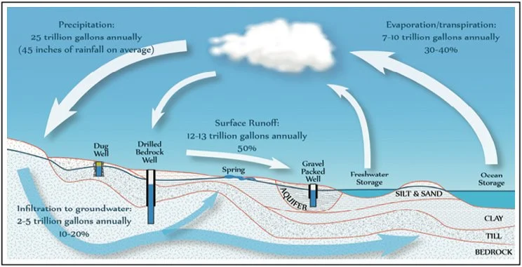
Figure 1: Maine’s Water Cycle
The aquifer sediments that were deposited along the west side of Pollack Brook exhibit springs, including Bella Luna Spring. Rain and snow that fall in the watershed recharge the aquifer and groundwater resource throughout most of the year. This natural cycle of water occurs across Maine and includes precipitation, runoff, infiltration to groundwater and evaporation/transpiration, as illustrated in Figure 1.
DEFINITION OF A SPRING
A spring is the location where groundwater (water that exists beneath the earth’s surface) naturally emerges from the ground. Spring water is withdrawn at the Bella Luna Spring site from one borehole, which intercepts a portion of the spring water that would otherwise naturally emerge from the ground. The spring water here naturally flows into Pollack Brook, which then flows north into the Penobscot River.
WATER WITHDRAWALS
The Lincoln Water District (LWD) owns and operates the spring water borehole at the Bella Luna Spring site. The Maine Drinking Water Program (DWP) of the Department of Health and Human Services regulates transportation of spring water in containers greater than 10 gallons. The DWP reviewed and permitted an application by BlueTriton, including a detailed hydrogeologic evaluation report, to transport spring water from LWD’s Bella Luna Spring site. In issuing it’s permit, the DWP required that purchase and transport of spring water by BlueTriton have no unreasonable adverse effects on the quality and quantity of water available at the LWD’s municipal water supply wells, private domestic wells, wetlands or Pollack Brook. In addition to requiring extensive scientific investigations of the site, the DWP established a series of conditions in connection with issuing the water transport permit. These performance standards protect the aquifer and other natural resources.
Hydrologic analyses were used by regulators to establish a maximum extraction volume from the Bella Luna spring source of 172 million gallons (MG) of water per year. This volume of water has been withdrawn historically by LWD to serve its customers with no adverse impacts to other water resources. While this may seem like a large number, this amount represents only 5.4 percent of the average annual precipitation falling in the Pollack Brook watershed. During 2022, BlueTriton purchased 71.56 million gallons of spring water from LWD, which is approximately 42 percent of the permitted volume and approximately 2.2 percent of the average annual precipitation falling in the watershed.
During 2023, BlueTriton purchased 48.01 million gallons of spring water from LWD, which is approximately 42 percent of the permitted volume and approximately 2.2 percent of the average annual precipitation falling in the watershed.1
SITE MONITORING
Aquifer and Surface Water Health
LWD and the DWP, as a condition of its permit, require BlueTriton to contract with independent scientists to regularly and thoroughly monitor the groundwater system, springs, wetlands and surface water bodies located in and around the Bella Luna Spring aquifer. The extraction rate at the spring water borehole is monitored continuously. Monitoring also includes aquifer levels, spring flow, flow in Pollack Brook and wetland water levels in and around the Bella Luna aquifer. These considerable monitoring efforts ensure that BlueTriton spring water purchases are sustainable and do not adversely affect the groundwater, surface water, or natural environments in the area. These independent scientists submit quarterly monitoring data and an annual report to the LWD, DWP and Maine Department of Environmental Protection (MDEP), where they are available to the public for review.
Wetland Health
Regular wetland monitoring includes measurement of the water levels in wetlands near Bella Luna Spring. During 2023, these measurements were within the natural range measured since 2017, before BlueTriton began purchasing spring water from LWD, and indicate that there has been no adverse effects on wetlands.
RECENT MONITORING RESULTS
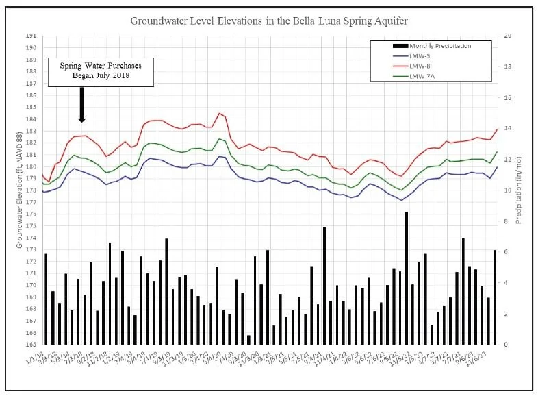
Figures 2 and 3 below summarize important measures of the health of the natural groundwater and surface water systems. Figure 2 depicts water levels measured in the Bella Luna Spring aquifer from January 2018 through the end of 2023. The water levels in the aquifer naturally fluctuate by a few feet, depending on the season. Spring snow melt and fall rains typically increase recharge resulting in rising groundwater levels in the aquifer, while growth and uptake of water by plants in the summer usually decreases aquifer water levels, as does the lack of recharge during winter months when the ground is frozen.
In Figure 2, water level trends observed at the site reflect normal seasonal variation that is expected during the year in response to changes in precipitation and temperature. Beginning in October 2022 and continuing through 2023, the Bella Luna Spring area experienced a higherthan-normal amount of precipitation. The monitoring data during that period show groundwater levels rising from the fall of 2022 through May 2023 due to aquifer recharge from precipitation and snow melt, remaining steady during the summer, declining slightly in the late fall, then rising again in December due to the high rainfall. At the end of 2023, aquifer levels had risen approximately 3 to 4 feet above the September 2022 levels and were similar to levels measured in the spring of 2020.
Figure 2: Groundwater Monitoring Data
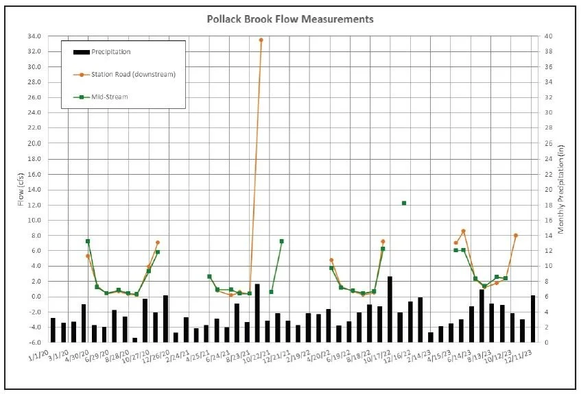
Surface water bodies, such as Pollack Brook, respond similarly to the natural hydrologic cycles, as shown in Figure 3. Melting snow and rains lead to increased surface water flows in the spring. Hotter, drier weather, combined with the uptake of moisture by plants, reduces surface water flows in the summer. As plants die back and the weather cools, surface water flows often increase in the fall.
Figure 3: Surface Water Monitoring Data
Figure 3 shows that the flow in Pollack Brook varies widely during the year. Typically, there are high flows in the spring when the ice and snow melt. Once the spring freshet of water drains from the watershed, flows in Pollack Brook naturally drop to low values. During the summer, the upstream portion of the brook naturally becomes stagnant with little or no flow past the beaver dams. The data in Figure 3 shows that in 2023, summer flows were somewhat higher than in the previous few years, maintained by above-normal precipitations. In October 2023, the flows in Pollack Brook rose as water uptake by the vegetation ended. Flow at the mid-stream station were too high to safely measure in October. During the winter Pollack Brook freezes and no flow measurements are collected.
As seen in Figure 3, the 2023 low flow in Pollack Brook was limited to July because of the above-average mid-year precipitation. During 2020, 2021 and 2022, low flow conditions in Pollack Brook began earlier in the year and ended later in the year compared to 2023.
FUTURE MONITORING
LWD and BlueTriton take their environmental stewardship responsibilities seriously and are committed to sustainable management of natural resources. Monitoring the groundwater, surface water, habitat and precipitation will continue for as long as spring water is withdrawn from the Bella Luna Spring site.
SUMMARY
Spring water purchases by BlueTriton at Bella Luna Spring in Lincoln, Maine are overseen by its independent hydrogeologists, the Lincoln Water District and the Maine Drinking Water Program. LWD and BlueTriton manage for sustainability through proactive monitoring and responsible water use to prevent adverse impacts to groundwater, surface water, wetlands, or other natural resources.
RESOURCES & INFORMATION
BlueTriton is committed to increasing the transparency of our operations and water stewardship practices through our Reading Room.
Questions about Bella Luna Spring or the information contained in this summary can be directed to:
Water withdrawals from Bella Luna Spring are regulated locally and at the state level by:
• Lincoln Water District
• Maine Dept. of Environmental Protection
• Maine Dept. of Health & Human Services
(Maine Drinking Water Program)
*Footnotes:
The percent withdrawal is derived by taking the annual withdrawal divided by the total rainfall within the watershed that year. A watershed is an area of land and its streams and rivers that drain to a single body of water, such as a larger river, a lake or the ocean.


